Great Outdoors
About the Bluff Lands
The Mississippi River bluff lands in Monroe, St. Clair and Randolph Counties, Illinois, are a unique and distinctively beautiful natural community.
The bluff lands constitute approximately 130,000 acres that are among the most resource-rich natural areas in Illinois. At the foot of limestone cliffs, remnant and recreated wetlands host a rich bird life and serve as summer herpetofaunal breeding grounds. Atop the cliff face, isolated patches and ribbons of loess hill prairie perch precariously. Within the deep upland forest that courses eastward from the bluff facing, and even rarer habitat type — limestone glades — shines in the sunlight.
Expansive forest, still in largely unfragmented blocks, sweeps up, down and along the steep ravines characteristic of karst terrane. Both forests and agricultural fields that undulate across the region are pockmarked and punctuated by 10,000 steeply sloped sinkholes and more cave openings than any other region of the state. The wetlands, cliffs, hill prairies, forests, glades, and the subterranean ecosystems sustain more than 40 state-endangered / threatened plant and animal species and seven globally-rare / endemic animal species found nowhere else on earth.
Unlike most of Illinois, the bluff lands never underwent Pleistocene glaciations, and are a geographic extension of Missouri’s Ozark Plateau. The bluffs corridor dramatically marks the transition from the Mississippi River bottomlands to the vast till plain characteristic of most of Illinois. Because of its unique geologic history, forest composition, and the presence of many rare “ozarkian” plants and animals not found elsewhere in Illinois, the bluff and corridor is known to scientists as the Illinois Northern Ozark Natural Division.

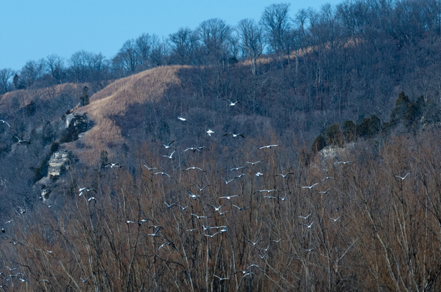
Gulls soar from Kidd Lake Marsh along the bluff face at Fults Hill Prairie Nature Preserve. Tom Rollins, Thomas Rollins Photography.
The biological diversity of the bluff lands is remarkable. The corridor provides habitats for 80% of Illinois’ species of mammals, over half of Illinois’ species of reptiles and amphibians, nearly one half of the state’s species of butterflies, over 200 of 300 species of birds regularly occurring in Illinois, and nearly 1000 of 3200 species of vascular plants in the state. Over a dozen threatened or endangered plant and animal species live in the corridor.
The bluff lands also host nearly one half of all of Illinois’ remaining loess hill prairies. Illinois’ largest hill prairie complex, Fults Hill Prairie Nature Preserve, was designated a National Natural Landmark by the U.S. Park Service In 1986. There are only 600 such landmarks in the entire United States.
Explore the Great Outdoors
We invite you to join us and explore the Great Outdoors of our bluff lands. Clifftop manages and stewards the White Rock lands, which our organization jointly owns with HeartLands Conservancy. Additional partnering organizations steward more of our Great Outdoors areas and help make hiking adventures to these lands possible: the Salt Lick Point Stewardship Committee and the Friends of Stemler Cave Woods.
![CLIFF TOP map [Converted]](http://www.clifftopalliance.org/wp-content/uploads/2011/09/CLIFF-TOP-map-Converted-810x1024.jpg) The area map shown here depicts many of our favorite great outdoor sites.
The area map shown here depicts many of our favorite great outdoor sites.
Driving directions to and trail maps for White Rock Nature Preserve, Salt Lick Point Land and Water Reserve, and Stemler Cave Woods are provided by clicking on the links here, or within the information section for those areas on this website.
Driving directions to and a trail map for White Rock Nature Preserve.
Driving directions to and a trail map for Salt Lick Point Land & Water Reserve.
Driving directions to and a trail map for Stemler Cave Woods Nature Preserve.
There are numerous additional areas available to outdoor recreationists in Southwestern Illinois; whether you want to go hiking, birding, enjoy panoramic vistas, view wetlands, and look at our photograph wildlife, you have many choices.
The Illinois Department of Natural Resources operates a number of sites in our area, including Fults Hill Prairie Nature Preserve and Kidd Lake Marsh State Natural Area; Randolph County Conservation Area; and Peabody-River King State Fish & Wildlife Area. Several of these sites offer additional outdoor activities, such as camping, fishing, and horseback riding trails. Access further information about IDNR by clicking on this link to their website: http://www.dnr.illinois.gov
The Kaskaskia River Project and Kaskaskia Lock and Dam, located at the confluence of the Kaskaskia and Mississippi Rivers offers the fun of water sports for fishing, boating, skiing, and the serenity that water-watching can provide. The Lock and Dam has camping sites and a day use area available, and offers daily tours of the lock facilities, free of charge. The river confluence offers excellent winter viewing of American Bald Eagles (we hope to see you at the annual February Eagle Trek at the Lock and Dam!) and year-round viewing of the bountiful wildlife and human activities that abound on the Kaskaskia and Mississippi Rivers. Access additional information about the Kaskaskia River Project and activities at the Lock and Dam by clicking on the link to their website: http://www.mvs.usace.army.mil/Kaskaskia/

